Best Hikes in Zermatt
A comparison of Zermatt's finest walks read the way the valley works — by altitude, lift access and weather. The Five Lakes loop, the Matterhorn Glacier Trail, the Gornergrat ridge and the gentler valley paths, ranked by difficulty, view and who they suit.

Photo: Chris Holgersson / Unsplash
- ✓More than 400 km of marked trails fan out from the village and the lift stations — far more than any one trip can cover.
- ✓The smart way to hike Zermatt is to ride a lift for the height and walk a traverse, not a climb: most signature routes go gently downhill.
- ✓For the cleanest Matterhorn reflection, the Five Lakes Walk and Stellisee win; for raw ice and rock, the Matterhorn Glacier Trail.
- ✓Even an easy, well-marked trail here is high alpine ground — check the weather, the lift calendar and the snow line before you set out.
How to read Zermatt's trails — by altitude, not address
Zermatt is a vertical place, and its walking is best understood the same way the village understands everything else: by height. The car-free village sits on the valley floor at 1,608 m; the trails climb from there to ridges and glaciers above 3,000 m, and the lifts exist precisely so you do not have to grind up every metre on foot. The single most useful idea for planning a hike here is this — ride a lift to gain the altitude, then walk a traverse or a gentle descent rather than a slog uphill. Almost every famous Zermatt route is designed around that logic.
What that gives you is an unusually generous menu. You can step off a funicular at Blauherd and be among reflection lakes within minutes; ride the cog railway to a ridge at 3,089 m and stroll down past a glacier; take the cable car towards the ice and walk a stark high-alpine line with the Matterhorn close enough to feel its weather. The same network means a hard morning and an easy afternoon can sit side by side, and a family with small children and a couple chasing a 4,000 m horizon can both have a perfect day from the same village.
This guide compares the walks the way you would actually choose between them: by difficulty, by how much the lifts do for you, by the quality of the Matterhorn view, by whether they suit families, and by season and weather risk. It is a shortlist, not a catalogue — the best of the network, ordered so you can match a trail to your morning, your forecast and your legs.

At a glance: choosing your hike
A quick way to match a walk to your day. Heights, lift names and broad difficulty are evergreen; exact opening dates, the snow line and walking times shift with the season and the weather, so confirm conditions and the lift calendar before you set out.
- Want the Matterhorn doubled in still water? Five Lakes Walk (Blauherd–Sunnegga side) — easy to moderate, mostly downhill.
- Want ice, moraine and high-alpine drama? Matterhorn Glacier Trail (Trockener Steg–Schwarzsee) — moderate, high and exposed.
- Want the biggest panorama for the least effort? The Gornergrat ridge walks (Gornergrat–Rotenboden–Riffelberg) — easy to moderate.
- Hiking with young children? Leisee and the Sunnegga family paths, or the short Riffelsee loop — short, gentle, with a reward at the end.
- Short on a clear-weather window? Stay low: the valley and Gorner Gorge paths work even when the tops are in cloud.
- Chasing autumn colour and quiet? Late September to October on the Sunnegga-side lakes, when the larches turn gold.
 Five Lakes WalkThe lake-by-lake route, the dawn timing and the reflection at Stellisee.
 Matterhorn Glacier TrailThe high, stark traverse between Trockener Steg and Schwarzsee, with glacier views and safety notes.
 Gornergrat hikesWalks off the cog railway, with train-stop flexibility from Gornergrat down to Riffelalp.
1. The Five Lakes Walk — the romantic one
If you only walk one trail in Zermatt, this is the one most people remember. The Five Lakes Walk traces the Sunnegga side of the valley, linking five mountain lakes — Stellisee, Grindjisee, Grünsee, Moosjisee and Leisee — and the first of them, Stellisee, holds the most beautiful reflection of the Matterhorn in the whole network. On a still, cold morning the entire pyramid falls upside down into the water, pink at the tip if you have timed sunrise. It is the picture that brings people to this side of the mountain.
Ride the Sunnegga Express funicular from the village and the gondola on to Blauherd to start high, then walk down anticlockwise so the route is mostly gentle descent with the Matterhorn ahead of you. It is well-marked and popular — which is part of its character — but it is still high, exposed ground, and snow can linger into early summer. Reckon on a half-day at an easy pace, longer with photo stops, a flask and the patience to wait out the wind for a glassy lake.
This is the walk for couples, for anyone who wants the signature reflection, and for a first proper day on the trails. Go early both for the calm water and to be ahead of the crowds, and let the morning itself be the destination rather than a stop on the way somewhere else.

2. The Matterhorn Glacier Trail — the dramatic one
For raw mountain rather than soft reflection, the Matterhorn Glacier Trail is Zermatt's most spectacular marked day walk. It runs across the high western flank of the valley between Trockener Steg, reached by cable car at around 2,939 m, and Schwarzsee at roughly 2,583 m — a descending traverse through moraine, bare rock and the cold breath of the glaciers, with the Matterhorn looming so close it dominates the sky. Information boards along the way explain the ice, the geology and how far the glaciers have retreated, which gives the walk a quiet, sobering thread beneath the spectacle.
It is graded moderate, and the grading is honest. The terrain is rocky and uneven, the altitude is real — you start near 2,900 m and never drop far below 2,500 m — and the weather can turn fast and cold this high, even in summer. This is not a stroll; it wants proper boots, layers, water and a respect for the mountain. But for fit walkers it delivers an experience closer to the world of the climbers than any other day route from the village, finishing at the little chapel and lake of Schwarzsee with the option of a cable car back down.
Choose this one on a clear, settled day when the tops are open and the forecast is kind, and treat the lift status as part of your safety check, not an afterthought.

3. The Gornergrat ridge — the biggest view for the least work
The Gornergrat Bahn — Switzerland's first fully-electric rack railway, running since 1898 — lifts you to an open-air station at 3,089 m, level with 29 four-thousanders and looking straight across the Gorner glacier to the Monte Rosa massif and the Matterhorn. From the top a family of walks fans down the ridge, and the genius of them is that the cog railway has intermediate stations — Rotenboden, Riffelberg, Riffelalp — so you can walk as much or as little as your legs and the weather allow, then catch the train for the rest.
The short, famous stretch is the descent from the summit to Rotenboden and the Riffelsee, the Gornergrat side's own reflection lake, where the Matterhorn doubles in a small dark pool a few minutes below the station. Carry on down to Riffelberg and beyond for longer, gentler ridge walking with the glacier always in view. Most of it is easy to moderate, the surface is good, and the panorama is arguably the grandest in the valley — which is why it suits anyone who wants the big-mountain horizon without a hard climb, including families, provided you mind the altitude and the exposed weather up top.
Because the train gives you an escape at every stage, the Gornergrat walks are also the safest choice on a day with uncertain weather: start down, and if the cloud comes in or legs tire, the next station is never far.
Gornergrat hikes — full guideEvery walk off the cog railway, with train-stop flexibility from the summit to Riffelalp. RiffelseeThe Gornergrat-side reflection lake, a short walk below Rotenboden.
 Gornergrat guideThe cog railway, the viewpoints and the weather strategy for the highest open-air station in Europe.
4. Gentle and family walks — Leisee, Sunnegga and the lake paths
Not every great Zermatt walk is a half-day among the four-thousanders. The Sunnegga side, reached by the quick underground funicular, has a cluster of short, gentle paths built for families: Leisee, the bathing lake just below Sunnegga at around 2,232 m, has a level shore walk, a swimming lake warm enough for children in high summer and a playground, making it the easiest possible introduction to high-alpine walking with small legs in tow. From there a child can manage the lower section of the Five Lakes loop without trouble.
Elsewhere the network has plenty of short, rewarding loops — the Riffelsee circuit off the Gornergrat line, the meadow paths around Riffelalp, the marked trails through Findeln's hamlet of larch chalets where the terraces serve a long mountain lunch. These are the walks for a half-day, for younger children, for older walkers, or simply for an afternoon when you want the mountain without the mileage. The trick is the same as ever: let the lift do the climbing, and keep the walking gentle and downhill.
Keep an eye on the weather even here. A short family path is still high ground, the sun is fierce at altitude and afternoon storms build quickly in summer, so carry layers, sun protection and water however modest the route looks on the map.

5. Low and weatherproof — the valley and gorge paths
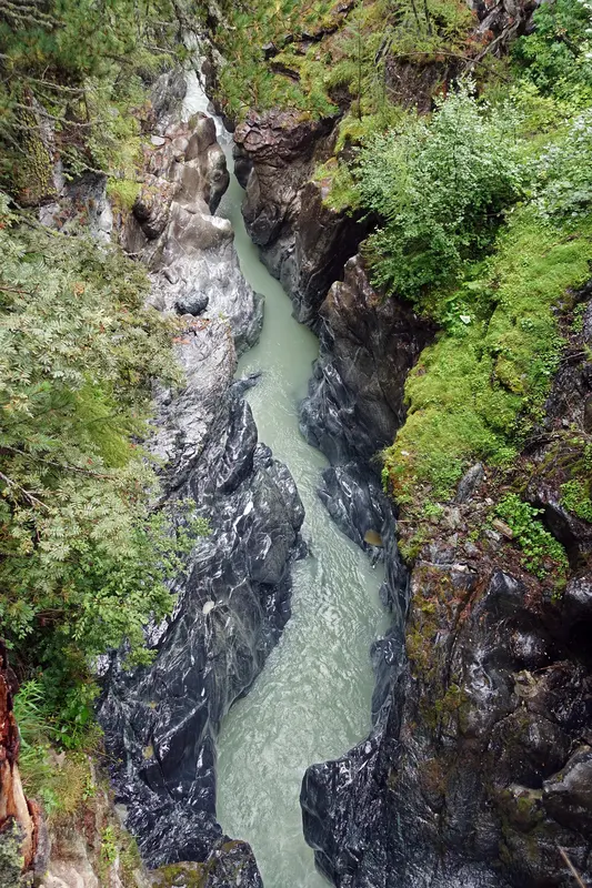
When the tops are in cloud, the wind is up or the lifts are shut, the valley floor still has good walking. Marked paths run south of the village towards Furi, Zmutt and the hamlets, threading larch woods, old timber chalets and pastures with the Matterhorn appearing and disappearing between the trees. They are low enough to stay below most weather, gentle enough for almost anyone, and they show you a quieter, older Zermatt than the lift stations do.
The standout low-level excursion is the Gorner Gorge, a deep, water-carved slot in the rock reached on foot from the village, with walkways pinned to the cliff above the rushing meltwater of the Gornervispa. It is a short, dramatic detour that works on a grey day and delights children, and it pairs naturally with a walk out to Furi and a mountain-restaurant lunch.
These are the routes that save a day the weather would otherwise spoil — and they are worth doing on a fine day too, as the slower, more intimate counterpoint to the high traverses.

Difficulty, season and what to carry
Swiss trails are waymarked by difficulty, and the colour codes are worth knowing. Yellow signs mark easy hiking paths suitable for most people in good shoes; white-red-white marks mountain trails that are steeper, rougher and more exposed and want proper boots and surefootedness; white-blue-white marks alpine routes that demand real mountain experience. Most of the walks in this guide are yellow or white-red-white; read the signs at the trailhead and be honest about the harder grade.
The hiking season runs roughly June to October. Early summer can leave snow on the higher traverses and the upper lakes only just thawed; July and August are warm, busy and prone to afternoon thunderstorms that build fast over the peaks; late September and October bring golden larches, thinner crowds and the clearest, coldest light — many regulars' favourite season — but shorter days and the first snows. The lifts that make the walks possible run to a seasonal calendar, so always confirm that the stations you need are open before you commit a day to a route.
Whatever you walk, pack for a mountain: sturdy footwear, layers including a windproof, sun protection that takes the altitude seriously, more water than you think you need, food, and a charged phone with the weather and lift status checked that morning. The walking here is generous and well-organised, but it is real high country, and the same lifts that make it easy can close and leave you to find your own way down.
- Yellow = easy path; white-red-white = mountain trail (boots, surefootedness); white-blue-white = alpine route (experience required).
- Season: roughly June–October; snow can linger early, larches turn gold late September into October.
- Summer afternoons bring thunderstorms — start early and be off the high ground by mid-afternoon.
- Carry boots, layers, sun protection, water, food and a checked weather and lift forecast.
- Confirm the lift calendar before you plan a hike around riding up — stations run seasonally.
Building a hiking trip: how the walks fit together
Over a few days the walks layer naturally by side of the valley. Give the Sunnegga side a morning for the Five Lakes and Stellisee; give the Gornergrat side a day for the ridge, the Riffelsee and the train-stop flexibility; give the Matterhorn side a clear, settled day for the Glacier Trail to Schwarzsee. Keep a low-level day in reserve — the gorge, the valley paths, Findeln — for whenever the weather closes the tops, and you have a week that never wastes a forecast.
The discipline that makes it all work is watching the weather and keeping the big view flexible. Hold the headline traverse open until the forecast firms up, spend the clearest morning on the Glacier Trail or the Gornergrat ridge, and fill the uncertain days with the lower, weatherproof walks. Do that, and Zermatt rewards you with the rare thing in the high Alps: a network big enough that there is always a right walk for the day you have been given.


Five Lakes Walk Guide
Zermatt's most-loved easy hike, lake by lake — how to reach the start by funicular and gondola, which way to walk, where the Matterhorn reflects, how long it takes and the dawn timing that makes the picture.
Read guideBest Gornergrat Hikes
Scenic walking off the Gornergrat cog railway, where every intermediate station is an escape. The ridge descent to Riffelsee and Rotenboden, the longer Riffelberg and Riffelalp routes, and how the train-stop flexibility lets you walk as much or as little as the day allows.
Read guideMatterhorn Glacier Trail Guide
A high-alpine traverse between Trockener Steg and Schwarzsee, through moraine and bare rock with the Matterhorn looming close — how to reach it by cable car, which direction to walk, the glacier story along the way and the safety the altitude demands.
Read guideMore in Hiking & Summer
6
Best Family Hikes in Zermatt
Child-friendly hikes in Zermatt chosen by lift access, gentle effort, picnic and lake stops, playground rewards and an easy weather backup — so the whole family enjoys the mountain.
Read guide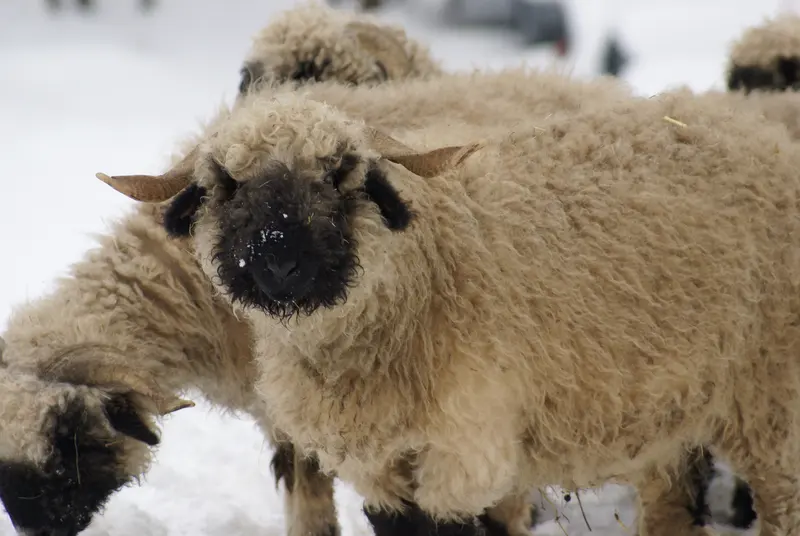
Blacknose Sheep in Zermatt
Where and when to meet the Valais Blacknose — the curly-horned, black-faced sheep of the Matterhorn valley — and how to watch them with respect.
Read guide
Charles Kuonen Suspension Bridge
How to reach and walk the Charles Kuonen suspension bridge above Randa near Zermatt — rail access, the climb from the valley, the bridge itself, head-for-heights notes and weather sense.
Read guide
Easy Walks in Zermatt
Gentle, low-effort walks in and above Zermatt — the village and riverside, the Furi forest, Riffelalp's level paths and the Sunnegga-area strolls — for non-hikers, families and mixed-ability groups.
Read guide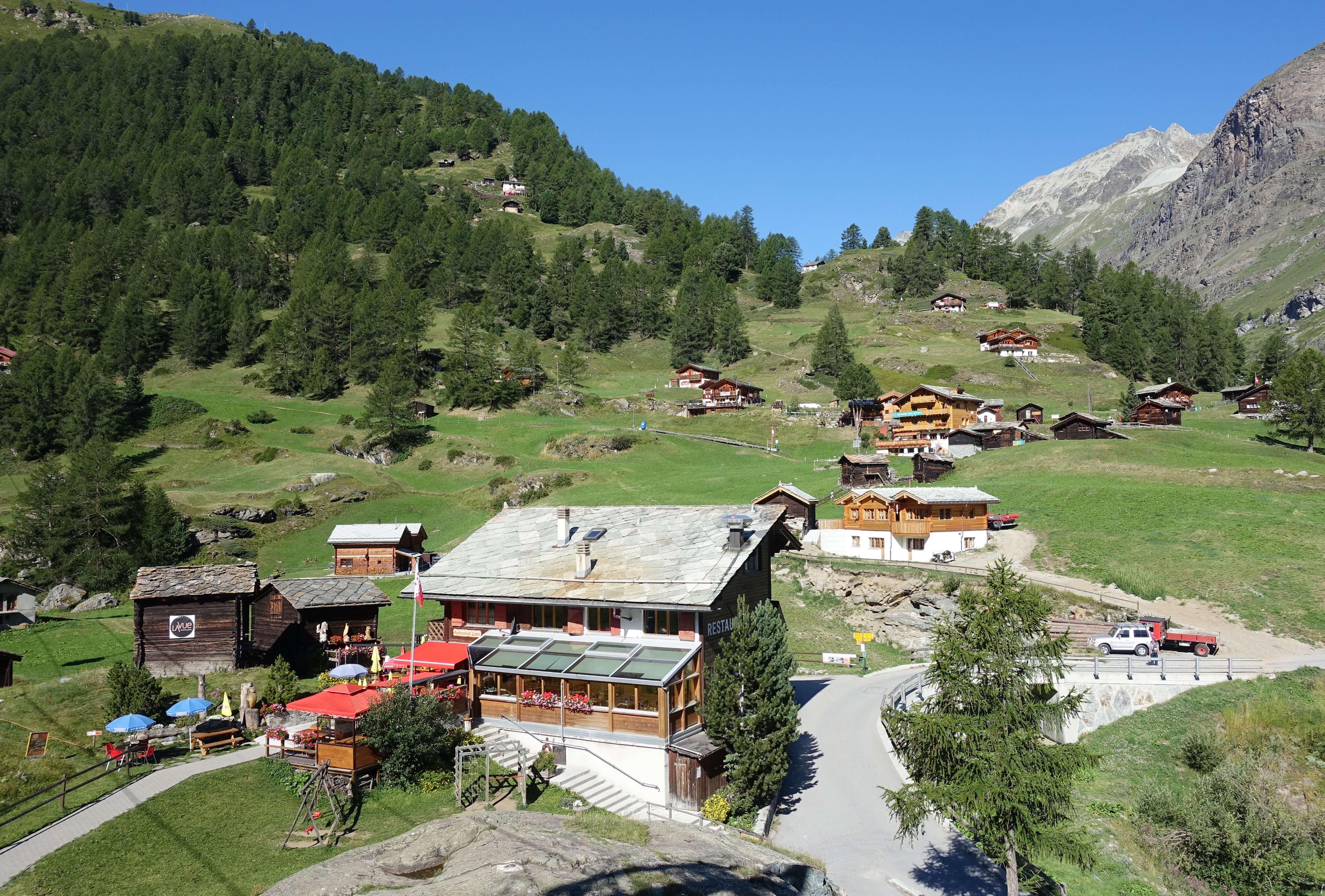
Furi Area Guide
The Matterhorn-side hamlet and lift junction above Zermatt — gentle forest walks, the suspension bridge, the Gorner Gorge, terrace restaurants and an easy family half-day, all reached on foot or by cable car.
Read guide
Furi Suspension Bridge Guide
How to walk to the Furi suspension bridge above Zermatt — the short forest route, the Gorner Gorge add-on, the easy lift cheat, and where to stop for lunch in the Furi hamlet.
Read guide